How to Track Friends' Cars on a Road Trip: 5 Ways
To track friends’ cars on a road trip, put every driver on one shared live map for the length of the trip. Phone-based group maps beat texting, dropped pins, and item trackers because they show all vehicles moving at once, and the good ones stop sharing when the drive ends.
The short version
- One map, not one share per person. Eight friends on one-to-one sharing is 8 pins and 8 expiry times to manage.
- You’re tracking phones, not cars — unless you’ve wired a dedicated GPS unit into the vehicle.
- Phone GPS is accurate to about 4.9 m (16 ft) under open sky, per GPS.gov, and worse under bridges and trees.
- Item trackers like AirTag report last-seen positions, not live movement, so they can’t follow a moving convoy.
- Drive-scoped apps hold up to 20 people on one live map at $0 and end sharing when the drive ends.
We built Vamio after too many night drives where the tracking worked fine and the coordination still failed — the map was accurate, and the phone was face-down in a cupholder. Most of what follows is about that gap.
What’s the best way to track friends’ cars on a road trip?
The best method is a single shared map that every car joins for the trip and that closes itself afterward. One-to-one location sharing scales badly: with eight friends, you’re managing eight separate shares, eight permission prompts, and eight different expiry times, and no one ever sees the whole group in one view. A group map inverts that — everyone joins once, and every car appears on the same screen. The second thing to check is how the sharing ends. A tool that stops when the trip stops is safer than one that waits for you to remember, because the trip ending is something you were going to do anyway.
You’re tracking phones, not cars
Almost every consumer method tracks a phone, and the phone happens to be in a car. That distinction stops mattering right up until the moment it does. A passenger who steps out at a rest stop takes the group’s only marker for that vehicle with them. A dead phone drops the car off the map while the car keeps driving.
Only two setups really track the vehicle. A hardwired or OBD-II GPS tracker reports the car’s own position and keeps reporting when phones die. A factory connected-car service does the same through the manufacturer’s app. Both are built for fleets and stolen-vehicle recovery, and neither shows you six friends’ cars in one view — which is the actual road-trip problem.
For a weekend trip, phone-based tracking is the right trade. Just plan around the failure mode: one phone per car, mounted and charging, and a driver who knows they’re the marker for that vehicle.
How accurate is phone GPS when you’re moving?
Accurate enough to tell which exit someone took. GPS.gov states that GPS-enabled smartphones are typically accurate to within a 4.9 m (16 ft) radius under open sky, and that accuracy worsens near buildings, bridges, and trees (GPS.gov). At 65 mph a car covers about 29 meters every second, so a 4.9 m position error is roughly a fifth of a second of travel — invisible at highway speed.
The number that actually degrades your experience isn’t accuracy, it’s update frequency plus cell coverage. A position fixed to 4.9 m but reported 90 seconds ago puts a car a mile and a half from where the map shows it. In canyons, tunnels, and rural dead zones, every phone-based method fails the same way, and the fix is procedural rather than technical: agree on a regroup point before you lose signal.
Five ways to track friends’ cars, compared
| Method | What it actually locates | Live? | Ends by itself? |
|---|---|---|---|
| Shared group drive map | Every phone in the group, on one screen | Yes | Yes — when the drive ends |
| One-to-one live location (maps or messaging app) | One friend’s phone, per share | Yes | Only if you set a timer |
| Family-safety tracker | Household members, continuously | Yes | No — built to stay on |
| Item tracker in the car (AirTag, Tile) | The tag’s last reported position | No | Not applicable |
| GPS or OBD-II vehicle tracker | The vehicle itself | Yes | No — it’s hardware |
Read the last two columns together. The first row is the only one that shows the whole group at once and turns itself off. That’s why it fits a trip better than tools built for a household or a fleet.
Why item trackers in the glovebox don’t solve this
An AirTag or Tile dropped in a friend’s car looks like a cheap fix and behaves nothing like one. These tags have no GPS and no cellular radio. They report position only when someone else’s phone passes close enough to relay a Bluetooth signal, which means what you see is a last-seen location, not a moving dot. On an empty interstate at 2 a.m., the nearest relaying phone may be twenty minutes behind you.
There’s a consent dimension too. Apple ships unwanted-tracking alerts that notify people when an unknown AirTag or compatible Bluetooth tracker is traveling with them, and directs them to disable it (Apple Support). A tracker your friend didn’t agree to is likely to set that alert off partway through the trip, which is a worse conversation than just asking everyone to join a map.
What does drive-scoped car tracking look like in practice?
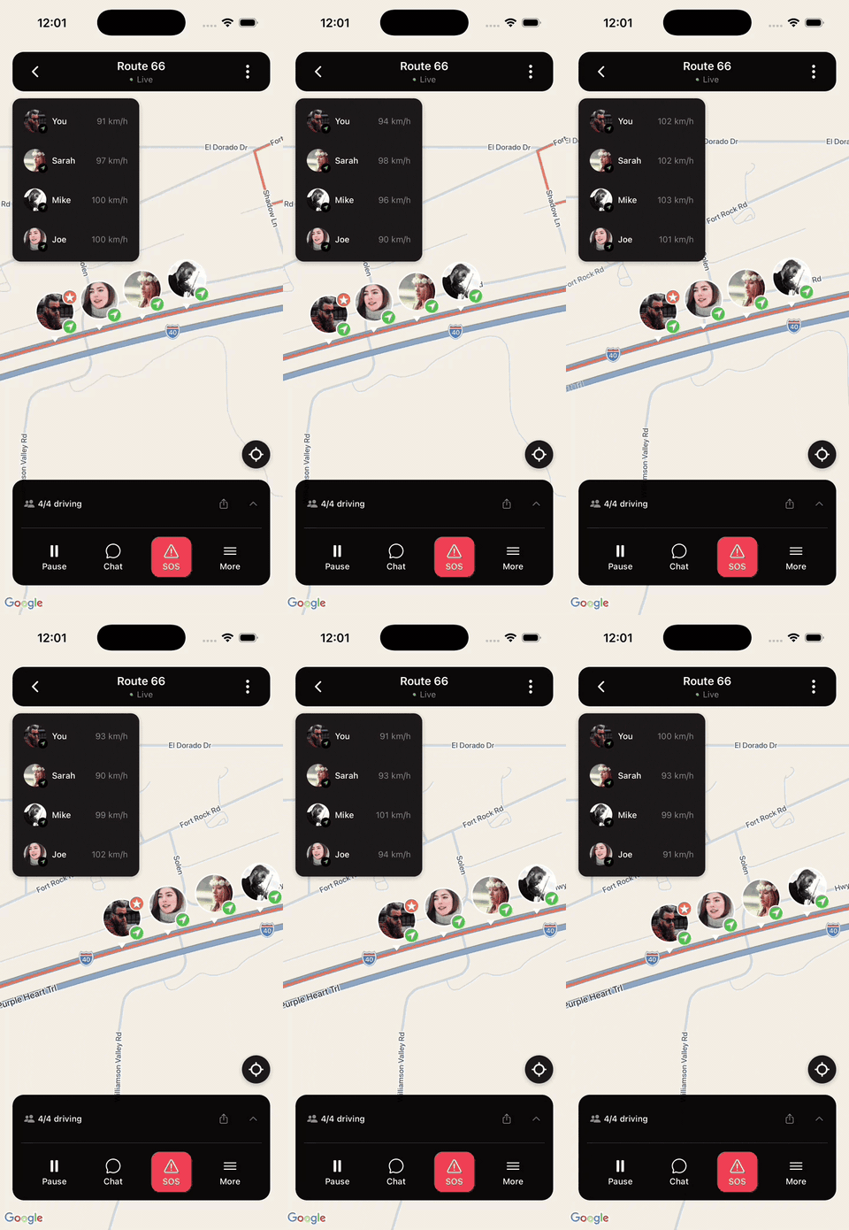
Drive-scoped means the tracking session is the trip itself. Everyone joins one map, the map runs while the group drives, and it closes when the drive ends. Group-driving apps like Vamio work this way: the crew joins a single drive by invite link with no sign-up, and location is accessed only during that active drive, with no background tracking, no data sale, and no ads (how we handle safety and privacy). The free plan puts up to 20 people on one live map at $0, and larger groups split into parallel drives. An hour-long drive uses roughly 5–10 MB of data, on iOS 16+ and Android 10+. There’s in-drive chat and a one-tap SOS that sends your exact location to everyone in the drive.
How do you set this up before you leave?
Set it up the night before. Seven steps:
- Pick one method for the entire group. Two apps means nobody sees everybody.
- Send the invite link the evening before, so late joiners aren’t a parking-lot problem.
- Assign one phone per car as that vehicle’s marker, and say out loud whose it is.
- Mount that phone and plug it in. Continuous GPS plus a bright screen drains a battery fast.
- Grant precise location, not approximate — approximate is far too coarse to tell exits apart.
- Agree on regroup points roughly every 45–60 minutes, before you’re relying on signal.
- Agree what a dropped pin means — usually: keep driving to the next regroup point.
Step 3 is the one groups skip. Without a named phone per car, two people in the same vehicle both show up on the map. Meanwhile a third car looks like it vanished, because its only passenger with the app fell asleep.
What to do when a car drops off the map
Assume signal, not trouble. A car that disappears from a live map has almost always driven into a dead zone, and the pin will reappear within a few minutes. Give it that time before anyone turns around, because a U-turn on a highway is a real risk taken against an imaginary one.
If the pin is still gone at the next regroup point, that’s when you act. Call the driver, not the passenger — the passenger’s phone is usually the one that died. Failing that, the last known position on the map is the useful thing: it tells you which exit they were near, and it stays visible after the signal drops. We wrote a fuller version of this in what to do if you get separated from your group while driving.
How do you track cars without distracting the driver?
Design the trip so nobody has to look. NHTSA estimates that 3,275 people were killed in distracted-driving crashes in 2023. Reading or sending a text takes a driver’s eyes off the road for about 5 seconds — at 55 mph, roughly the length of a football field driven blind (NHTSA). A live map is only an improvement over a group chat if it replaces the glancing rather than adding to it.
Three habits do most of the work. Mount the phone at eye level so checking the map costs a glance instead of a reach. Let passengers own the map and the messages in any car that has one. And agree the plan before departure, since a group that knows where it’s regrouping doesn’t need to check anything for the next 45 minutes.
Track the trip, not the people
Tracking friends’ cars on a road trip is a coordination problem wearing a technology costume: one shared map that ends with the drive solves it, and eight separate location shares don’t. If you want the wider version, start with how to keep a group together on a road trip, or compare the underlying options in the best way to share your location with a group temporarily.
Vamio is a free group-driving app for road trips, convoys, and car meets on iOS 16+ and Android 10+ — start a drive, send one invite link, and the crew joins with no sign-up. Location is shared during the drive and stops when it ends. Download Vamio, or read who we are first.
